Winmalee Rural Fire Brigade added 2 new photos.
Did you know –
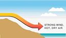
A layer of warm air sitting over a layer of cold air is called a temperature inversion. Inversions are common during the night and early morning when cool night air collects close to the ground. This arrangement of air is stable because cold air near the ground is heavy and tends to stay near the ground. The warm air above the inversion is lighter and tends to stay above the inversion. There are often strong winds in the warm air above inversions, but while the inversion lasts these winds cannot come down to ground level. As the sun heats the ground during the day, the inversion weakens and strong winds may begin to blow near the ground. This is one reason why many bushfires burn more fiercely in the afternoon, as happened with the fires in Hobart in 1967. Sourced from Bureau of Meteorology, Please contact us or visit the Bureau of Meteorology for more information.